
Editor’s Note: There have been some problems with the site server the last few days. If you have trouble with the link, it usually comes back up in a minute or two.
I actually had something else ready to publish today and it’s folly to publicly call where a hurricane will land several days in advance, but given this is my first ever namesake hurricane, I feel obligated to step up.
Note, if you want ongoing updates, check out my twitter (@informedbyian) where I’ll try to keep current thoughts updated.
Before we get into where this storm is going, when I wrote recently about it being a quiet hurricane season and any pickup would lead to fish storms because everything in the Atlantic this year is expected to recurve, I left out one big caveat (in order to save space and not add a digression).
Atlantic storms are still unlikely to make US landfall as we saw with Fiona. However, Caribbean storms are a different story.
In fact, one of the better analogs for this year is 2012 which was also a very quiet year until…Sandy, which was, wait for it, a Caribbean storm that went through Cuba before heading north.
So this was the most likely risk for the US and it has now come into play. What does it mean for those in Florida and surrounding states?
Analog Storms
Interestingly, two of the better parallels are other ‘I’ storms though there is perhaps a third more on target.
Hurricane Ivan
Ivan hit Alabama in 2004. It has a lot similarities to the current storm. It’s only one letter off(!) and went just a hair west of Cuba before turning north. There was a lot of fear at the time it would hit Florida before it tracked west. By missing Cuba, it was able to drift further west.
Hurricane Irma
Irma hit the west coast of Florida in 2017 and has since destroyed many Florida carriers with specious AOB claims. Irma went just north of Cuba before turning. This means it didn’t get weakened by going over the island.
Hurricane Charley
Charley in many ways is the best analog to Ian. It was a Caribbean storm that went through western Cuba, proceeded to southwest Florida, and then emerged into the Atlantic after beating up Orlando.
The Current Forecast
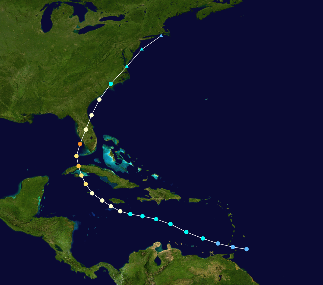
The projected path at the time of writing is for the storm to pass over the western part of Cuba, then head north towards Florida, and making landfall either on the west coast or panhandle of the state. Most models are favoring the west coast as the more likely landfall.
There is more confidence in this forecast than typical for a storm several days out given the likelihood of contact with Cuba and some of the steering trends to the west and north. I normally like to make a bold call about an unexpected deviation from the models but I’m not seeing it this time.
Intensity
While this will likely be a major hurricane over water, current projections are that it will drop to a 2 by landfall. If I had to bet, I’d suggest the intensity will be higher.
First, the Gulf is extremely hot right now which creates the potential for rapid intensification. Second, the forecasts are likely counting on Cuba to weaken the storm.
If Ian does an Ivan and skates to the west of Cuba, there is nothing to weaken it and it could really blow up. If it goes over Cuba as expected, it is expected to be a slow moving storm and have time to reorganize.
Interestingly, while normally a storm headed towards the panhandle would be stronger than one going to the west coast (more time over the warm ocean water), there are some winds in the forecast that would weaken a panhandle storm upon approach.
Thus, a west coast hit would likely result in a stronger storm which is concerning given that is where the higher insured values are.
Location
Note, the more of Cuba it passes over, the more likely it is to land over western Florida. If it goes over far western Cuba, it is more likely to end up in the panhandle.
If it misses Cuba altogether, it may miss Florida altogether and end up in Alabama, Mississippi, or even Louisiana. However, this is now considered to be a low probability.
There are some other unusual factors to consider. This storm could stay out just over the ocean for a day or two and expose much of the west coast to the powerful right side winds. Given the slow speed of the storm, a coast hugger could do a tremendous amount of damage.
It also could track northeast across the state like Charley in 2004 and then re-emerge in the Atlantic and pose a risk to the Carolinas.
That being said, it would still not be surprising to see it head due north and hit the panhandle as a weak category 3 at landfall though the odds of this have declined at each update. Financially, this would probably be the best case for the insurance industry.
The Tampa Threat
What’s the worst case outcome for this storm? That’s simple. It hits Tampa. More specifically, it hits Tampa from the west, not the south.
A strong storm that enters the bay from the west would be devastating as that creates the most storm surge. Worse than Katrina. Worse than Harvey. Worse than Sandy. Downtown Tampa can be ten feet underwater pretty easily if surge comes through the bay.
This is already one of the biggest risks in the cat model catalogue. But think about how much Tampa-St.Pete has grown just in the last few years. Do you really think those models are up to date?
Fortunately, a cat 3 does a lot less damage than a 5 (which would be >$100B) but there is the concern about this being a slow moving storm which could produce a Harvey like flooding effect on top of devastating storm surge.
Obviously, this could put many of the remaining Florida carriers out of business. It would potentially result in large assessments out of Citizens for the ordinary homeowner. This could be the tipping point for the Florida insurance market.
Now, before you panic, the odds of hitting Tampa on the bullseye are low. But this storm poses probably the greatest risk of such an outcome since Charley.
Loss Potential
A few thoughts regarding potential losses. Demand surge will likely be much higher than in recent years given the shortages throughout the economy and lack of contractors. Whatever the normal demand surge function is, you probably need to add another say 20%.
While it’s too soon to have a strong conclusion on outcomes, one thing I’m comfortable saying is that losses will be a lot higher than expected if it goes to western Florida.
Places like Naples have much higher values than just a few years ago. How many of you are reading this from Naples? And how many lived somewhere else five years ago? So yeah, the cat models are going to be too low in their severity.
My current best guess is that the storm will land somewhere closer to the panhandle than Tampa which would likely keep insured losses <$10B. However, not all those paths are in the clear (imagine Cedar Key landing heading northeast through Gainesville and Jacksonville and back out into the Atlantic).
If you’re worried about worst case scenarios for insured losses, I’d rank them a) Tampa direct hit, b) slow moving coast hugger from Ft Myers to Tampa, c) Charley repeat hitting Orlando, and d) direct hit on Naples. Any of those could be $25B and potentially more.
However, as noted, there are plenty of other places on the west coast it could hit that would produce lower losses and most landfalls on the panhandle would be $10B or less.
Final Thoughts
Normally, the intrigue in these storms is where it will make landfall. There is a lot less variability around that this time. I think the real unknown is do we get this slow moving effect like a Harvey where the losses are far greater than the models would suggest given the wind speeds.
Additionally, the significant exposure growth in Florida combined with the heightened risk of demand surge increases the odds the loss estimate in the catalogue is too low (and that’s without even accounting for future AOB risk over time).
As I said at the top, I’ll keep updating thoughts as things develop on twitter for those interested.